Rand McNally 2022 Road Atlas Series
|
|
|
|
|
|---|---|---|---|
2022 Road AtlasThe Rand McNally Road Atlas is the most trusted and best-selling atlas on the market. This updated 2022 edition contains maps of every U.S. state and Canadian province, an overview map of Mexico, and detailed inset maps of over 350 cities and 25 national parks. Road construction and conditions contact information for every state conveniently located above the maps. Contains mileage chart showing distances between 90 North American cities and national parks along with a driving times map. Other Features Rand McNally presents “The National Parks by Decade,” a review of park history that begins more than a century ago, with the first wild and wonderful place to achieve park status—Yellowstone. Tourism websites and phone numbers for every U.S. state and Canadian province on map pages. ISBN: 0528023748 Also available: 2022 Road Atlas with Protective Vinyl Cover ISBN: 0528023772 |
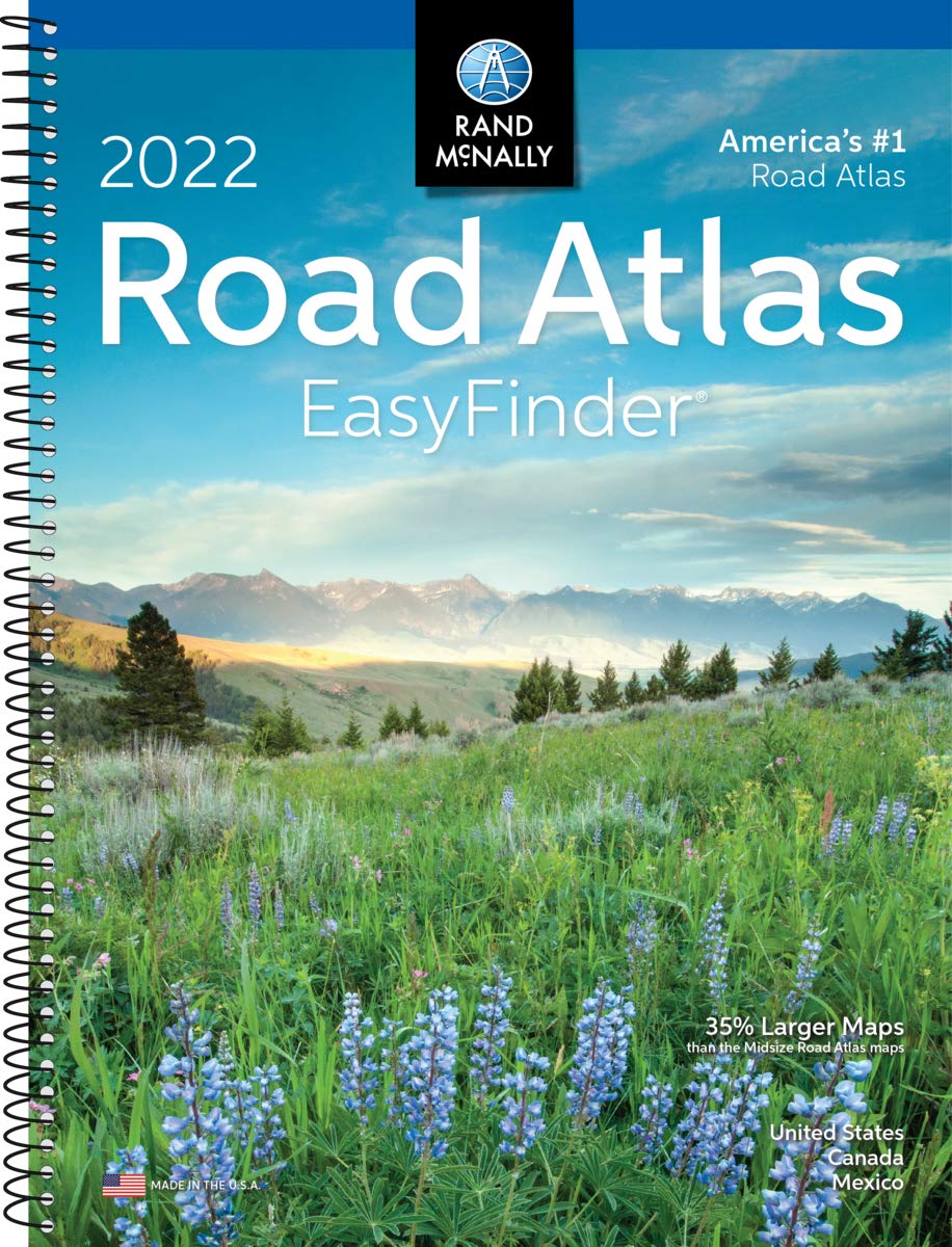
2022 Large Scale Road AtlasGive road-weary eyes a break with this spiral-bound Large Scale edition featuring all the accuracy you’ve come to expect from Rand McNally, only bigger. This updated atlas contains maps of every U.S. state that are 35% larger than the standard atlas version plus over 350 detailed city inset and national park maps and a comprehensive, unabridged index. Road construction and conditions contact information for every state conveniently located on map pages. Contains mileage chart showing distances between 77 North American cities and national parks with driving times map. Tough spiral binding allows the book to lay open easily. Other Features Rand McNally presents “The National Parks by Decade,” a review of park history that begins more than a century ago, with the first wild and wonderful place to achieve park status—Yellowstone. Tourism websites and phone numbers for every U.S. state and Canadian province on map pages. ISBN: 0528023780 |
2022 Road Atlas & National Park GuidePinpoint the best in the best: America’s national parks. With essential information and tips, hundreds of photos and maps, and a complete road atlas, this guide is all you need to have extraordinary park experiences. • A four-color, 132-page National Park Guide details the best of the best in each park—from trails, drives, and natural wonders to programs, museums, and lodges. • Hundreds of photos capture the essence of each park. • Park inset maps highlight key points-of-interest. • A completely updated 2022 Road Atlas. Updated maps of every U.S. state and Canadian province and an overview map of Mexico. Inset maps of over 350 cities and 63 U.S. national parks Road construction and conditions contact information for every state conveniently located above the maps Mileage chart showing distances between 90 North American cities and national parks along with a driving times map. Tourism websites and phone numbers for every U.S. state and Canadian province on map pages ISBN: 052802373X |
2022 Midsize Road AtlasThe most trusted and best-selling road atlas on the market made portable!. This updated 2022 edition contains maps of every U.S. state and Canadian province, an overview map of Mexico, plus detailed maps of over 50 North American cities, all conveniently packaged for travel. Includes a mileage chart showing distances between 77 cities and national parks with driving times map. Other Features Rand McNally presents “The National Parks by Decade,” a review of park history that begins more than a century ago, with the first wild and wonderful place to achieve park status—Yellowstone. Tell Rand! As much as we work to keep our atlases up to date, conditions change quickly and new construction projects begin frequently. If you know of something we haven’t captured in our atlas, let us know at randmcnally.com/tellrand. Road construction and conditions phone numbers and websites Tourism phone numbers and websites Hotel phone numbers and websites ISBN: 0528023799 |


Bob S. –
Spiral bound sturdy composition, easy to read maps and small enough to fit in the console or under your seat. The big problem I have with this little atlas is it doesn’t show all secondary and less traveled paved roads. I recently was on the Navajo Nation in Arizona wanting to get from Chinle, AZ to Page, AZ. Several roads that are perfectly safe for travel do not appear in this edition. Very basic.Thank goodness I brought my Garmin navigator along for back up as cell phone reception is almost non existent on the reservation unless you’re a tribal member that uses the tribal owned cell phone company. Once in Page, AZ I found the Rand McNally full sized 2022 atlas. The full size atlas is very complete and much better detailed. I threw this little atlas in the motel garbage can and continued on with the new large edition.The only thing this “EasyFinder” atlas is good for is if you stick primarily to interstate roads. I don’t recommend it.
Dina L. Voutour –
Perfect! We will use this a lot. It is very current!
Returning customer –
Excellent, very readable travel atlas for those of us who have found that gps, electronic maps have led us astray, the long way, looking for highways that have been closed etc
Mrflashlite54 –
I bought these after our last trip to see our grandaughter. Garmin took us so far out of the way I decided I would never travel without one again. I will still use Garmin but double check things with this Road Atlas also.
Susie Griffith –
Even with all of our group technology today my husband prefers using maps. He loves this atlas.Maps are printed well on durable paperThis Atlas will be staying in our car as we travel across the USA
G Bird –
I was dismayed when I could no longer purchase this map book at Sams Club or Costco. But lo and behold I looked on Amazon and there is was. Its great to use Google for short trips, but when you are going across the country and need to figure out what city is about 500 miles for driving to make hotel reservations, there is nothing better than using this map book.
Rob –
This road atlas is much more easily handled and manageable than the larger sized edition. It is a comprehensive, easily handled road atlas of the United States of America.
Gibbskeg –
Love the spiral bound for travel up to date in case gps fails or if you are like us and want to plan trips really helps in the idea of how far? My dad is 72 and wasn’t so small he had issues either with reading glasses
lisabee –
The last time we had a road atlas, it was a 2006 one. It was GIGANTIC! But since time has changed things AND since we now need it more for school, I wanted to update one that was just as good–but easier to store. So I opted for this one. It’s PERFECT! Has all the great things about the initial one, but a size that easily fits on my bookshelf.
Leigh –
This is a good addition to my car. It fits into the seat pocket of the back of my seat. Good to have for road trips when gps isn’t always reliable.